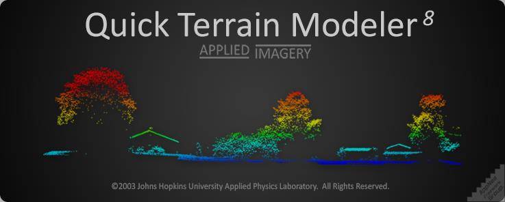
快速地形建模是世界上首屈一指的三维点云和地形可视化软件包。Quick Terrain Modeler设计用于激光雷达,但也足够灵活以适应其他3D数据源,它提供了易于使用的软件体验,允许用户处理更多数据、渲染更大的模型、更快地分析数据以及导出各种产品。这些优势使得地形开发变得非常强大、简单和直观。
快速地形建模师8.3.2.1 win系统 破解版 大小解压后:993M
形象化
快速地形建模器允许您使用最佳数据表示来可视化大量数据,以便进行分析和开发。快速地形建模器可以将收集的点可视化为点云中的点、DEM中的网格面,或者同时显示两者。显示数据后,用户可以使用可视化工具(如自定义照明、自定义高程调色板、模型着色和高程夸大)来增强视图。
剥削
将数据转化为有用的信息。这些有用的信息可以回答问题,帮助决策,并有助于规划。不同的用户部门提出的问题和做出的决定千差万别,但一个一致的主题是,开发必须快速、准确、互动、易于学习,并且易于与他人分享。快速地形建模器就是所有这些东西。
生产
激光雷达点云和DEM本身就是了不起的成就,但最终收集数据是为了帮助规划和决策。Quick Terrain Modeler利用直接导出到预先制作的PowerPoint模板、有用的3D注释工具、可以显示图像和/或符号的标记、直接导出到GPX/Garmin GPS设备和AVI视频飞行工具等工具,省时省力地创建演示文稿。
建设
QT Modeler可以处理两种预建的模型(DEM的,DTED的,等等)。)或原始点数据。从原始点数据(通常为LAS格式)开始,用户可以从这些文件中构建点云或表面模型(或两者都有)。创建表面模型时,QT Modeler提供了各种各样的网格和三角测量选项。
Quick Terrain Modeller (USA) 8.3.2.1 Win
Info:
Quick Terrain Modeler is the world’s premier 3D point cloud and terrain visualization software package. Designed for use with LiDAR, but flexible enough to accommodate other 3D data sources, Quick Terrain Modeler provides an easy to use software experience that allows users to work with significantly more data, render larger models, analyze data faster, and export a variety of products. These benefits enable very powerful, yet simple and intuitive, terrain exploitation.
VISUALIZATION
Quick Terrain Modeler allows you to visualize vast amounts of data using the best data representations for your analysis and exploitation. Quick Terrain Modeler can visualize the points as collected in a Point Cloud, as a gridded surface in a DEM, or display both simultaneously. Once you have the data displayed, the user can enhance the view using visualization tools such as custom lighting, custom elevation palettes, model coloration, and elevation exaggeration.
EXPLOITATION
Turn data into useful information. This useful information can then answer questions, assist in decision making, and contribute to planning. The questions being asked and decisions being made will vary widely between user sectors, but a consistent theme is that the exploitation must be fast, accurate, interactive, easy to learn, and easy to share with others. Quick Terrain Modeler is all of these things.
PRODUCTION
LiDAR point clouds and DEM’s are wonderful achievements by themselves, but ultimately the data was collected to assist in planning and decision making. Quick Terrain Modeler takes the time and the trouble out of creating presentations with tools like direct export to pre-made PowerPoint templates, useful 3D annotation tools, markers that can display images and/or symbology, direct export to GPX/Garmin GPS devices, and AVI video fly-through tools.
BUILD
QT Modeler can work with both pre-built models (DEM’s, DTED’s, etc.) or with raw point data. When starting with raw point data, typically in LAS format, users can either build point clouds or surface models (or both) from these files. When creating surface models, QT Modeler offers a wide variety of gridding and triangulation options.
云桥网络 为三维动画制作,游戏开发员、影视特效师等CG艺术家提供视频教程素材资源!
1、登录后,打赏30元成为VIP会员,全站资源免费获取!
2、资源默认为百度网盘链接,请用浏览器打开输入提取码不要有多余空格,如无法获取 请联系微信 yunqiaonet 补发。
3、分卷压缩包资源 需全部下载后解压第一个压缩包即可,下载过程不要强制中断 建议用winrar解压或360解压缩软件解压!
4、云桥网络平台所发布资源仅供用户自学自用,用户需以学习为目的,按需下载,严禁批量采集搬运共享资源等行为,望知悉!!!
5、云桥网络-CG数字艺术学习与资源分享平台,感谢您的赞赏与支持!平台所收取打赏费用仅作为平台服务器租赁及人员维护资金 费用不为素材本身费用,望理解知悉!